

William Jackson and Andrew Graves listed as taxpayers below were men of color who lived in West Point, VA. Research continues about the various locations of each building that was used in town for the education of African American children. Oral history is invaluable, but digitized records and the discovery of the “burned” King William County records open doors previously closed for documentation. We will continue to update this timeline as additional information is discovered. We encourage everyone to contribute their knowledge and sources to the community narrative.
Timeline
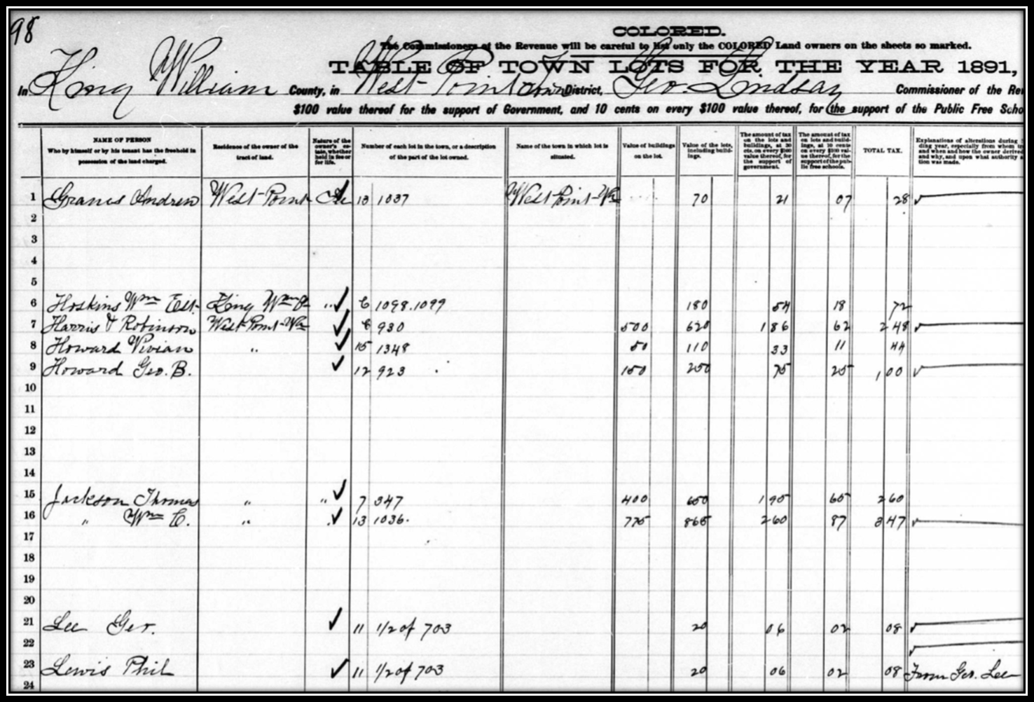
1885-1908 King William County Land Book Lots 1036 and 1037
| Year | Taxpayer Lot 1036 | Taxpayer Lot 1037 |
| 1885 | Richard McDonald of New Brunswick, New Jersey (no building) | Richard McDonald of New Brunswick, New Jersey (no building |
| 1886 | Richard McDonald (no building) | Richard McDonald (no building |
| 1887 | William Jackson (no building, notes in tax record say from Richard McDonald and wife by deed) | Peter H. Adams (no building) |
| 1888 | William Jackson (building value $150) | Andrew Graves (no building) |
| 1889 | William Jackson (building value $150) | Andrew Graves (no building) |
| 1890 | William Jackson (building value $775) | Andrew Graves (no building) |
| 1891 | William Jackson (building value $775) | Andrew Graves (no building) |
| 1892 | William Jackson (building value $775) | Andrew Graves (no building) |
| 1893 | William Jackson (building value $775) | Andrew Graves (no building) |
| 1894 | William Jackson (building value $775) | Andrew Graves (no building) |
| 1895 | William Jackson (building value $775) | Andrew Graves (no building) |
| 1896 | William Jackson (building value $100) Lot 1036 | Andrew Graves (no building) |
| 1897 | William Jackson (building value $100) Lot 1036 | Andrew Graves (no building) |
| 1898 | William Jackson (building value $100) Lot 1036 | Andrew Graves (no building) |
| 1899 | William Jackson (building value $100) Lot 1036 | Andrew Graves (no building) |
| 1900 | William Jackson (building value $100) Lot 1036 | Andrew Graves (no building) |
| 1901 | William Jackson (building value $100) | Andrew Graves (no building) |
| 1902 | William Jackson (building value $100) | Andrew Graves (no building) |
| 1903 | William Jackson (building value $100) | Andrew Graves is no longer listed in the land book; lot 1037 not listed |
| 1904 | William Jackson (building value $100) | R and J.L. Bland (no building, lot value $60) |
| 1905 | William Jackson (building value $100) | R and J.L. Bland (no building, lot value $60) |
| 1906 | William Jackson (building is gone, lot value is $60) | R and J.L. Bland own lot 1037 on 13th and lots 936 and 937 on 12th; all lots listed on same line with building value of $550 |
| 1907 | William Jackson (no building, lot value $60) | R and J.L. Bland own lot 1037 on 13th and lots 936 and 937 on 12th; all lots listed on same line with building value of $550 |
| 1908 | W.E. Jackson (no building, lot value $60) | R and J.L. Bland own lot 1037 on 13th and lots 936 and 937 on 12th; all lots listed on same line with building value of $550 |
| 1909 | W.E. Jackson (no building, lot value $60) | R and J.L. Bland own lot 1037 on 13th and lots 936 and 937 on 12th; all lots listed on same line with building value of $550 |
1876-1884 King William County Land Book Lots 1036 and 1037
| 1876 | Charles L. Pearson owns “all unsold lots in the town” which were transferred to him from the West Point Land Company; lot 1041 is owned by Frances Page. Nine freedmen families were on the former “Taylor Farm” in this area after the Civil War and worked as sharecroppers. Early maps and other evidence suggest this is the same land where the previous plantation slave quarters were located (research continues). | |
| 1877 | John Whitbeck of West Point owned 140 lots which the land book notes indicate were transferred from Charles L Pearson by deed; he also owned lots 160 and 161 (no buildings). John Woodbridge of New Brunswick, NJ owned 138 lots; Richard McDonald and John Woodbridge owned 142 lots together (notes say from CL Pearson). | |
| 1878 | Richard McDonald and John Woodbridge of New Brunswick, NJ owned many lots (none listed by lot number, just total and no buildings on those lots); B.L. Hutchinson of Trenton, NJ owned lots 1035, 1038, 1039 and 1040 which indicate from J. Whitbeck by deed. | |
| 1879 | Richard McDonald owned 68 lots and John Woodbridge of New Brunswick, NJ owned 212 lots | |
| 1880 | Richard McDonald of New Brunswick, NJ owned 68 lots (no buildings); John Woodbridge owned 210 lots | |
| 1881 | Richard McDonald owns many lots; note in tax record says lots 1036 and 1037 from John Woodbridge by deed; John Woodbridge is listed in the tax record the same year with his residence as New Brunswick. He owned 172 lots including 666, 667, 668, 671, 672, and 677 from R. McDonald | |
| 1882 | Richard McDonald of New Jersey owned 68 lots (no building is valued and no lot numbers are listed); he also owned 144 lots with John Woodbridge (note says from Charles L Pearson by deed). | |
| 1883 | Richard McDonald owned 66 town lots; he also owned another 141 lots with John Woodbridge | |
| 1884 | Richard McDonald of New Jersey owned many lots but the lot numbers are not listed, only the total | |
